simSALUD: Design and implementation of an open-source wizard based spatial microsimulation framework
- GeoHealth Laboratory, University of Canterbury, New Zealand
- Carinthia University of Applied Sciences, Austria
- Galileo University, Guatemala
Cite this article
as: M. N Tomintz, B. Kosar, V. M García-Barrios; 2017; simSALUD: Design and implementation of an open-source wizard based spatial microsimulation framework; International Journal of Microsimulation; 10(2); 118-143.
doi: 10.34196/ijm.00159
- Article
- Figures and data
- Jump to
Figures
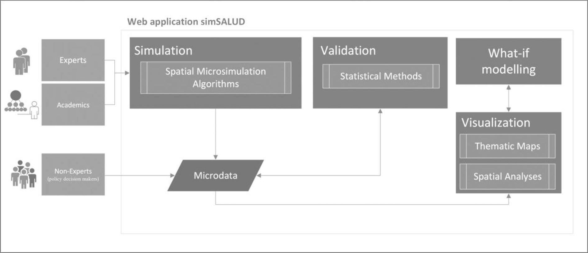
Figure 1

The core components of simSALUD dedicated to the target audience (experts, non-experts, and academics) (see also Tomintz & García-Barrios, 2017).
Figure 2
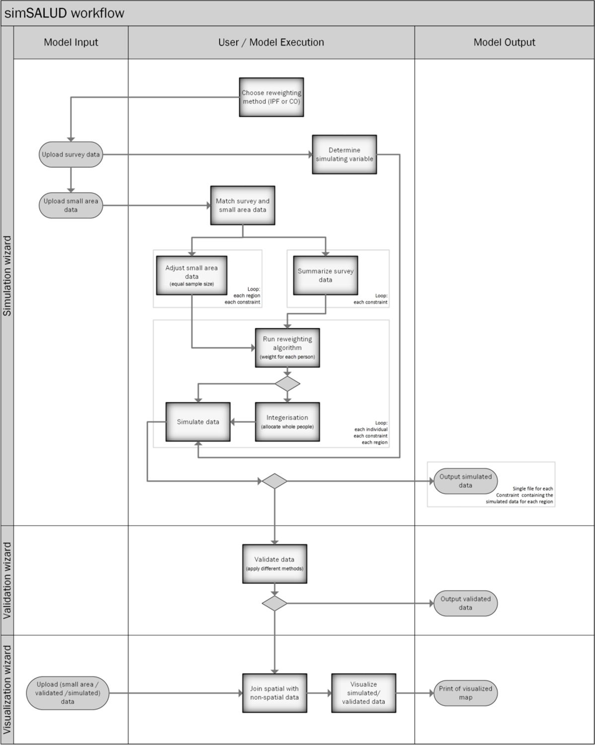
Workflow of the spatial microsimulation model using the simSALUD application.
Figure 3

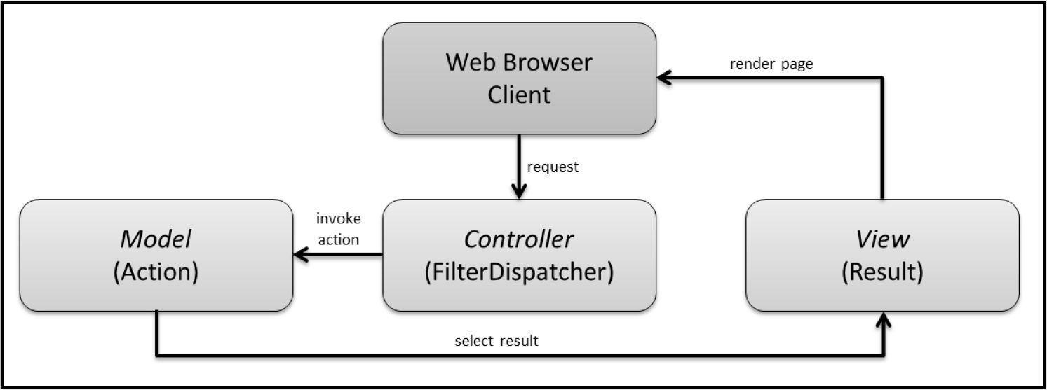
Struts 2 Model-View-Controller is realized by three application modules (Brown, Davis, & Stanlick, 2009).
Figure 4

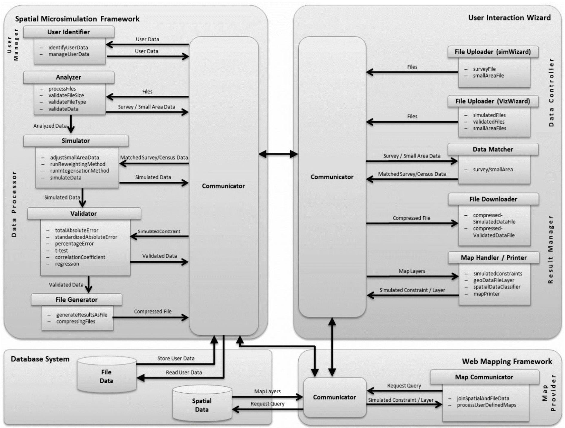
System architecture of the simSALUD application.
Figure 5
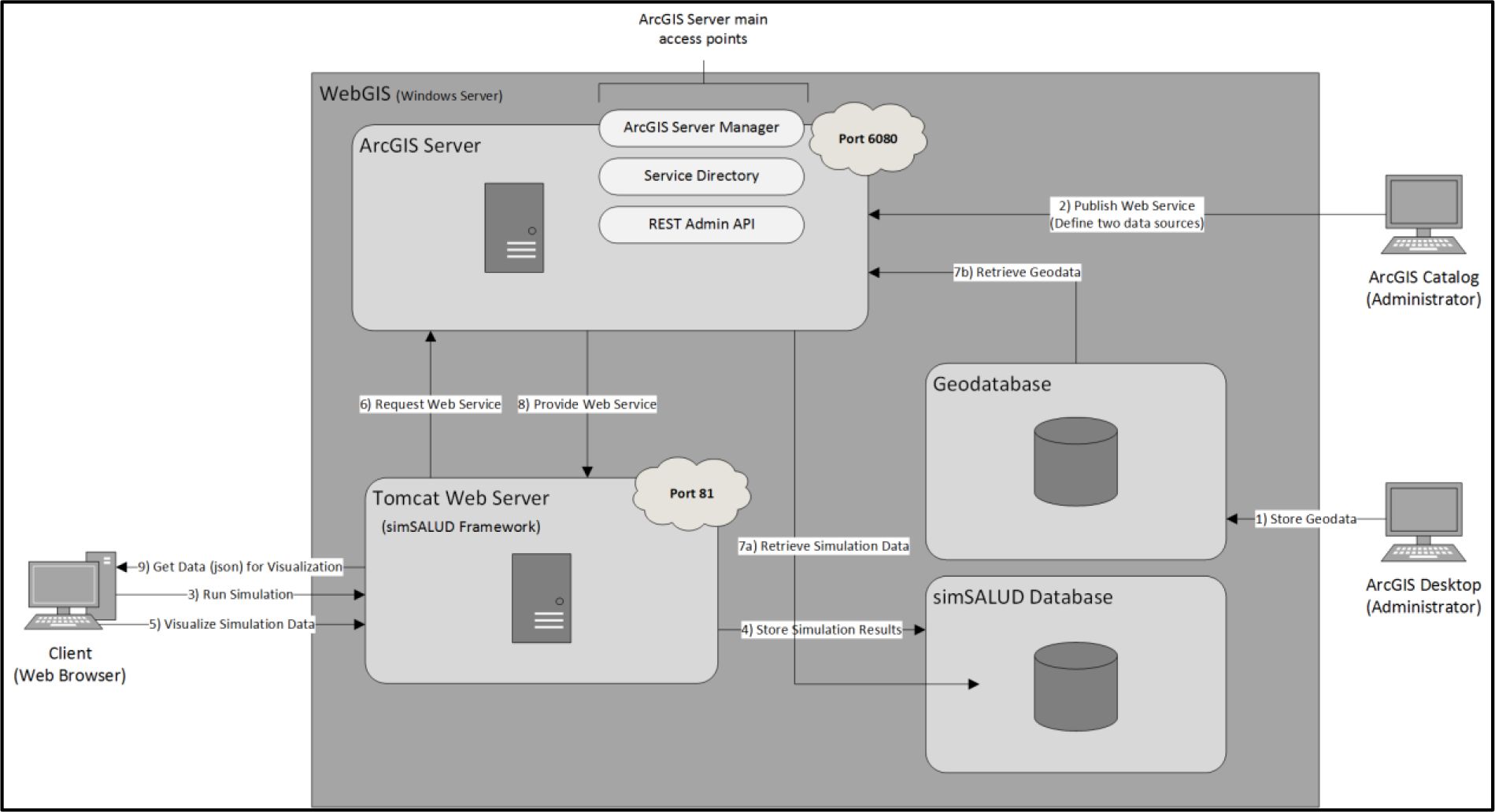

Server architecture with an interaction process to visualize simulation data.
Tables
Table A.1
Functional requirements for the simSALUD framework.
| Functional-Requirement | Functional-Requirement Description |
|---|---|
| Data upload | Users can upload their prepared .csv files through the application. The upload will be divided into two data parts: small area spatial data files and individual based files, e.g. survey data. |
| Choice of simulation algorithms | Users can choose one of the implemented algorithm before starting the simulation process. |
| Data match of input files | Spatial simulation requires a match between census and survey data. Therefore, an easy to use data match needs to be implemented, e.g. using drag and drop. |
| Contextual help | User receives context-sensitive help that describes one current state, situation, or feature by using hover/tooltip. |
| Simulation progress | During the simulation process, users should be able to follow the progress, e.g. progress bar, and follow the steps of the simulation process, e.g. information window. |
| Safe output data files | The simulation and validation results can be saved as a .csv files by downloading it to the users local drive. |
| Map visualization | A map window visualizes the simulated and validated data according to the chosen constraint straight after the simulation/validation execution. |
| Upload data for map visualisation | Users are able to upload previous simulated and validated data for mapping them. |
| Save/Print customized map as pdf | A pdf opens and the map can be printed or saved with the customized title, description, background map, etc. |
| Responsive for desktop, tablet | The application should be responsive for desktop computers/laptop and tablets. Mobile is low priority as its use for this purpose is questionable. |
Table A.2
Non-functional requirements for the simSALUD framework.
| Non-Functional-Requirement | Non-Functional-Requirement Description |
|---|---|
| Help / tutorial | A help/tutorial is required to guide users through simSALUD and include all relevant information. |
| GUI (Geographical User Interface) evaluation | A GUI evaluation is necessary using different target groups and to iterate this process after GUI improvements. |
| Expandability | The architecture of the application needs to be designed for future integration of functionalities, such as more algorithms or geospatial processing tools. |
| Accessibility | The application should be freely available and accessible via a web-based application. |
| Easy to use wizard | Users are guided through the application by using a wizard design approach. |
| Well-designed | A good design so that users find what they want and stay on the page to take actions. |
| Stability | Avoiding system failures and provide a robust model application. |
Download links
A two-part list of links to download the article, or parts of the article, in various formats.